Sarma and Under-Ice Operations

A September 17 TASS report indicated that Sarma, a Russian uncrewed underwater vehicle (UUV) currently under development by Lazurit Central Design Bureau, would be capable of long-term autonomous navigation and communication beneath the Arctic ice cap. A September 21 TASS report further indicated that Sarma's long range and endurance would be enabled by a Russian-built hydrogen-oxygen air-independent power (AIP) system.
According to TASS:
- "The Sarma underwater drone will be able to operate autonomously under the ice for up to three months, while transmitting data and receiving new tasks."
- "The autonomous unmanned underwater vehicle 'Sarma' will be able to dive to a depth of about 1 km, autonomously perform assigned tasks for three months and cover distances of more than 8 thousand km."
- "The functional demonstrator of the apparatus is planned to be manufactured in 2022-2023."
TASS also quoted Viktor Litvinenko, deputy head of the physical and technical research of the Advanced Research Fund (FPI), who indicated:
Regarding the vehicle:
- "The Sarma UAV is being created for long-term operation under the ice."
- "It is planned to control this apparatus under the ice, remotely."
Regarding AIP:
- "The air-independent propulsion unit using hydrogen and oxygen is planned to be developed."
- "The preliminary design has been developed. There are necessary conditions for the development of the AIP system."
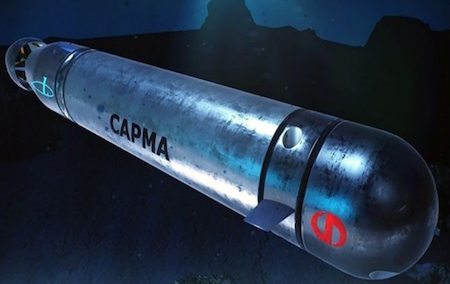
Sarma is an uncrewed underwater vehicle (UUV) developed by Lazurit Central Design Bureau.
-
While there is no agreed-upon industry or military standard for classifying uncrewed underwater vehicles, based on comparable vehicle classifications, Sarma would be considered a large displacement uncrewed underwater vehicle (LDUUV).
-
The vehicle is approximately 7.5 meters (25 feet) in length, and 1.5 meters (5 feet) in diameter, making it comparable to, or slightly larger than, the U.S. Navy's Snakehead LDUUV. Length and displacement may vary depending on installed payload modules.
-
The tentative language used by TASS and Mr. Litvinenko ("will be," "it is planned," "a functional demonstrator is planned to be manufactured in 2022-2023") suggests that the vehicle is still very much in the conceptual design phase, and that plans for full production to begin in 2024 may be optimistic.
-
Stock photos of a vehicle mock-up on display at Innoprom-2022 can be found here and here.
Developing an AIP system for a UUV poses a unique set of technological challenges, but it is achievable for Russia's highly skilled and experienced submarine industrial base. There is also precedent for AIP integration into Western AUVs.
-
The Cellula Robotics Solus-LR utilizes a hydrogen-oxygen fuel cell system combined with lithium ion batteries to enable a range of 2000 km.
-
The ThyssenKrupp Modifiable Underwater Mothership (MUM) XLUUV will be equipped with a hydrogen/Li-ion AIP system, enabling missions in excess of 700 km.
A greater challenge than energy will be underwater navigation and communication, challenging even under ideal environmental conditions, but more so in the Arctic where the ice pack largely prevents UUVs from surfacing to obtain a navigational fix or to transmit/receive data and tasking, and where dynamic conditions make for complex acoustics. In general, there are four ways autonomous underwater vehicles (AUVs) can navigate while submerged beneath the ice:
-
Inertial Navigation: Inputs from vehicle sensors such as a gyro compass or doppler velocity log (DVL) are used to determine heading and speed, which are then processed by an onboard computer to estimate position. While perhaps the least resource intensive option, inertial navigation is the least precise, and can result in errors that compound over time.
-
Long Baseline (LBL) - Involves the use of acoustic beacons moored to the seabed at fixed locations within an area of operations to act as navigational reference points. LBL is highly accurate, often within one meter and sometimes to within centimeters.
-
Ultra Short Baseline (USBL) - A variation of LBL, USBL utilizes an acoustic beacon that is attached to or suspended from a surface vessel to interact with a submerged target to determine its range and position. The benefit of USBL is that underwater vehicles can receive GNSS fixes to make for more precise navigation.
-
Satellite Navigation Buoy - Moored or floating buoys obtain a fix from an orbiting navigational satellite constellation, such as GPS (United States), Galileo (EU), BeiDou (China), or GLONASS (Russia), and use acoustic communication to transmit that fix through the water column. Although satellite navigation can be unreliable in polar regions, due to its higher inclination (64° versus 55° for GPS and 56° for Galileo) GLONASS would be uniquely positioned to facilitate accurate and reliable positioning for systems operating beneath the Arctic ice cap.
Long-range under-ice navigation and communication would necessitate a substantial deployment of supporting infrastructure. During ICEX 2020, for example, researchers from General Dynamics Mission Systems and MIT utilized "ICEX Tracker" - four acoustic buoys anchored to the ice, spaced just 2000 meters apart, and suspended between 30 and 100 meters beneath the icepack - to remotely control a single Bluefin-21 UUV from a nearby encampment.
-
It is possible that Russia could already have a distributed Arctic underwater navigation network in place. In 2016, Concern Okeanpribor announced that it had developed an "Underwater GLONASS" called Positioner, a network of floating and moored satellite navigation buoys that relay navigational data from orbiting GLONASS satellites and also provide a framework for an underwater communications network.
-
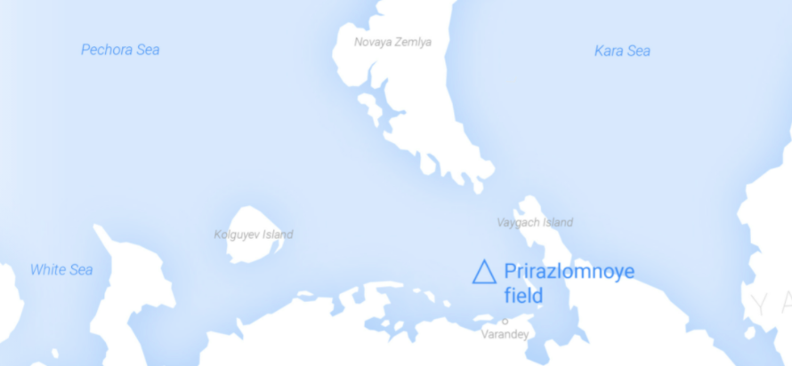
The first Positioner network was to have been deployed near Gazprom's Prirazlomnoye hydrocarbon production platform, located on the Pechora Sea shelf approximately 60 km from shore.

Russia has ambitious plans to exploit the rich natural resource deposits found in the Arctic basin, and to defend its regional economic interests. Sarma will have a role to play in both endeavors.
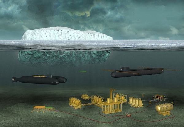
- Project Iceberg involves the use of specially designed crewed and autonomous submersibles to develop the Arctic's vast hydrocarbon fields, and to equip seabed production facilities with nuclear reactors to provide a source of ongoing power. Sarma could play a role in carrying out geological exploration, as well as inspection and, if equipped with robotic arms, maintenance and repair of energy and production infrastructure.

Source: Rubin Design Bureau
-
Along with resource exploitation, Russia will seek to secure its Arctic operations. As such, Project Iceberg will integrate a range of Subsea and Seabed Warfare (SSW) assets into its operational framework. One of these assets is the special purpose submarine Belgorod, a highly modified Oscar II SSGN which is essentially a mothership for a wide range of dual-use crewed and autonomous submersibles. Russia has also reportedly deployed a network of seabed acoustic sensors called Harmony. Sarma could be integrated into a broader Russian SSW network as an anti-submarine (ASW) picket or decoy, acoustically connected to a range of autonomous and crewed systems used to detect, identify, and engage NATO submarines.
-
Since its initial announcement in 2016, it is possible that the Positioner initiative could have been expanded at some point to encompass a larger swath of the Arctic, or perhaps folded into the larger Project Iceberg framework to enhance SSW operations.
While years away from operational deployment, Sarma represents Russia's continued commitment to advanced autonomous underwater systems as a means to both exploit and secure its Arctic economic interests.

